
|
The
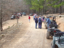
Wolf Pen Gap ATV trails are well known among outdoor
enthusiasts. Located approximately 8 miles east of Mena
Arkansas, the Wolf Pen Gap Trail Complex is a part of the
Ouachita National Forest and is regulated and maintained by the
Forest Service. There are four trailheads aligned with the
four points of the compass. To go to the West Trailhead,
t
There
are approximately 35 miles of loop trails in the Wolf Pen Gap
Trail Complex. The trailh |
|
 ravel east of Mena on 8 east for 1 mile to Arkansas 375, then
south 8 miles to the trailhead near County Road 277. For
the South Trailhead continue south on Arkansas 375 to the
trailhead on the Left. The North Trailhead is east of Mena
near Board Camp. Take Arkansas State Highway 8 east from
Mena to Polk County Rd. 61, travel 3.5 miles, turn right
at the sign, go 1/2 mile to the trailhead. The last
trailhead is the East Trailhead and is most easily found by
taking Hwy 8 east about 20 miles (about 1 mile east of Big
Fork), turn right on Polk County Rd. 83 (Forest Road 38), travel
5 miles to the East Trailhead.
ravel east of Mena on 8 east for 1 mile to Arkansas 375, then
south 8 miles to the trailhead near County Road 277. For
the South Trailhead continue south on Arkansas 375 to the
trailhead on the Left. The North Trailhead is east of Mena
near Board Camp. Take Arkansas State Highway 8 east from
Mena to Polk County Rd. 61, travel 3.5 miles, turn right
at the sign, go 1/2 mile to the trailhead. The last
trailhead is the East Trailhead and is most easily found by
taking Hwy 8 east about 20 miles (about 1 mile east of Big
Fork), turn right on Polk County Rd. 83 (Forest Road 38), travel
5 miles to the East Trailhead. eads have vault toilets and room
to park your ATV trailers. Some of the trails aren't for
the timid or inexperienced. There are three designated
helipads within the Wolf Pen Gap Trail Complex that are used on
a frequent basis by primarily
eads have vault toilets and room
to park your ATV trailers. Some of the trails aren't for
the timid or inexperienced. There are three designated
helipads within the Wolf Pen Gap Trail Complex that are used on
a frequent basis by primarily | Home | Government | Parks & Recreation | Schools | Lodging | Events & Seasonal | Auto Related | Clubs and Organizations | Chamber of Commerce | Regional Real Estate | Contact Us | Site Map |
Copyright © 2002-2009 Turner Diversified Services